Great Continental Divide Adventure Ride
Day 2 - Silver City to Grants, New Mexico
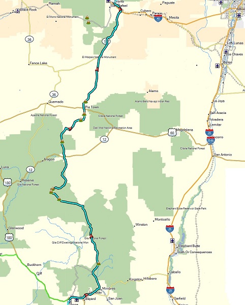 At
269 miles, this was one of the longest days of the planned route, with no
gas along the way. Lunch was planned in Pie Town, apparently known for
their pies (but not for their fast service). Some of the riders that
needed gas along with way, swung out to the town of Datil about 20 miles
east of Pie Town.
At
269 miles, this was one of the longest days of the planned route, with no
gas along the way. Lunch was planned in Pie Town, apparently known for
their pies (but not for their fast service). Some of the riders that
needed gas along with way, swung out to the town of Datil about 20 miles
east of Pie Town.
The terrain is quite scenic, being more mountainous through the Gila National Forest in the first half, with more open sage in the second half. The biggest challenge in this first portaion was a large flooded field of mud that some of us went down while trying to cross. This ended up being an initiation for a lot more of this to come…
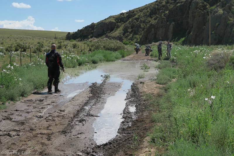
After an extremely lengthy wait for lunch and serving of what I thought was a pretty mediocre pie, our group was on the bikes again, heading north from Pie Town on CR-A083. By then, rain was starting to fall, just as we were entering a 15 mile long stretch of dirt that gave all of us a new found respect for New Mexico mud. This road started getting progressively worse with the rain, with one section becoming a mud-ageddon on one particular hilly section. Many of the riders went down at least once, with some getting their front fenders or chain guards clogged, and unable to get their front wheel to turn anymore, without having to manually clear it off. The V-Strom seemed particularly bad in this category with its more road-like clearances. An ingenious solution that one rider came up with to help clear this mud off the front wheel was to wrap a bungee cord across the wheel tread. This acted like a snow cable while also scraping the mud off between the fender and tire.
This is also the first big area where some bikes suffered some minor damage, ranging from broken wind screens, bent shifters, mirrors, rear brake pedals, or torn-off rear fenders. Fortunately I was able to survive this section intact, skating through without stopping, while trying to find dry patches or tracks that looked sufficiently compressed to have squeezed out some of the water. I noticed many had problems if they ended up stopping or slowing too much. If you kept some momentum and movement on the wheels, then the mud tended to fling off and not accumulate. Making a mental note of the fender clearance issue later, I noticed my F800GSA has about 1.5” while the 2015 V-Strom 650 is only about 0.5” and the Africa Twins are at about 1”. My 1.5” clearance seems to be a minimum and it never held me back on this trip, but a little more would be better. A few riders already had fender lift kits (or bikes without that problem), anticipating or previously experiencing this situation.
Once we escaped this mud (with another 15 miles of more improved dirt) before reaching Highway 117, and consulting with one of the locals passing through, we decided to hit the asphalt for the last 40 miles to our destination in Grants, and not subject ourselves to more of these conditions. This highway ended up being quite scenic, passing through the El Malpalis National Conservation Area, with beautiful sandstone buttes and the La Ventana Natural Arch to the east, and open lava fields to the west. With more time, it would be nice to revisit this area with better photographic equipment around the golden hour.
Images (click to select the larger view at bottom)


Intro Day 1 Day 2 Day 3 Day 4 Day 5 Day 6 Day 7 Day 8 Day 9 Day 10 Day 11 Day 12 Day 13 Conclusion
All content and images are property of Stephen Fischer Photography, copyright 2017. Last updated: 9/3/2017