Great Continental Divide Adventure Ride
Day 13 - Seeley Lake to the Canadian border, and then Rooseville, Montana
 The
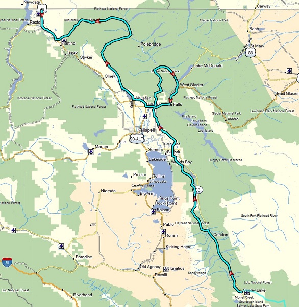
plan for the last day’s ride to the Canadian border was to be 247 miles.
Although already considered on the long side, because of a desire by most in
the team to take the longer red route into Glacier National Park, the actual
ride for our team ended up being about 300 miles.
The
plan for the last day’s ride to the Canadian border was to be 247 miles.
Although already considered on the long side, because of a desire by most in
the team to take the longer red route into Glacier National Park, the actual
ride for our team ended up being about 300 miles.
The first half of the ride for the day consisted more of these long relatively well graded dirt and gravel roads with the characteristic dust, requiring a fairly large separation. Sometimes a rider would miss a turn and have to double back, and each time hoping you could correct the situation before ending up getting behind somebody else's dust trail.
After lunch and gas in the more populous Columbia Falls, we then started toward Glacier National Park via the back road North Fork along the Flathead River. But after getting half-way through Glacier we had to turn around due to a bridge wash-out, and double back all the way to Columbia Falls that we left about two hours before. Ugh!
From here, heading north and then east, the road ended up being a mix of loose dusty dirt with a fair amount of fast oncoming truck traffic was we got closer to the Flathead River again (and now much further north). This required some caution in order to avoid from being another casualty like what happened to Jon (see one of the frame grabs from my GoPro below).
Some of this loose dirt got a little tricky on the big bikes due to the steeper slope conditions. Apparently this was due to recent repairs to sections of the road that had washed out in the spring run-off conditions, with the fill feeling a bit loose and not yet tamped down or covered in rock. After reaching the Flathead and taking in the magnificent views of the Canadian Rockies to the northeast, myself and one other rider (Randy) of our group independently missed a turn and almost reached the Canadian border at a closed crossing point, getting within about 4 miles before realizing the error. By then, we still had another 30 miles back over another mountain range, consisting of a lot of sharp shale rocks before reaching the asphalt for the final stretch to the border. During this last rocky section, I started to worry about getting a flat or destroying a tire (with my rear tire looking a lot more worse for wear). Being so close, and after going so far, I exercised more care to avoid the sharpest rocks and slow it down a bit.
This delay, combined with the wrong turn a ways back caused some consternation for Bill (Africa Twin) and Rich (KTM 990) who were patiently waiting down the trail on the asphalt at the last rendezvous point for about 30 minutes before the final push to the border. In general those two tended to be faster, while I stopped more for photographs. When I showed up ahead of Randy, despite him taking off ahead of me and Bill at the last rendezvous, concern started to grow. It turned out because he had taken the same wrong path that I had earlier, but took longer before correcting the situation, he ended up getting behind everybody else.
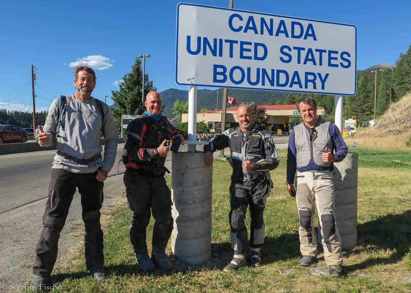
Reaching the Canadian border was the climax of the trip, as the day and mileage ended up being the longest and toughest of the entire ride. We did not get there until about 6 PM due to our previous setback from the closed road in Glacier, missed turns, and encountering a wide range of riding conditions, testing our endurance, navigation, teamwork, and off-road skills.
Images (click to select the larger view at bottom)


Intro Day 1 Day 2 Day 3 Day 4 Day 5 Day 6 Day 7 Day 8 Day 9 Day 10 Day 11 Day 12 Day 13 Conclusion
All content and images are property of Stephen Fischer Photography, copyright 2017. Last updated: 08/31/2017