Alaska-Canada Adventure Ride
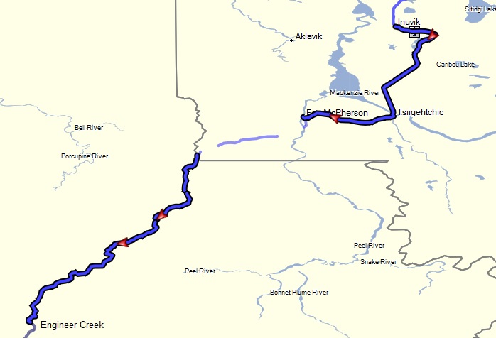
Day 12 - Inuvik, Northwest Territories to Engineer Creek campground, Yukon (285 miles)
 The official plan for the day was to reverse our path and stay in Eagle Plains again. But there was some discussion amongst our group that based on our pace so far, and assuming the road conditions held out, we could get farther for the night.
After passing Fort McPherson and as we got closer to the border with the Yukon Territories, mine and Randy's GPSs started to act up again. I had cleaned the contacts earlier, but for some reason they don't like this area. Or perhaps this area doesn't like them :^)
About 50 miles north of Eagle Plains Randy flatted on his tubeless rear tire. The rest of the group was ahead of him except for myself, tending to bring up the rear due to more frequent photography stops. But the damage to his tire was more of a slice, and the mushroom plugs that he brought for the trip turned out not to be adequate to fully seal the leak. The tire would only hold air for about 10 minutes of riding at a time, so we decided to just air it up, ride for about 10 miles, stop and repeat. The problem was aggravated by the relatively slow inflation rate of either of our portable air compressors. We repeated this process about five times before reaching Eagle Plains. Fortunately they had a garage there and were able to help Randy patch his tire from the inside for a more permanent fix.
Speaking of failures, the GoPro mount on my motorcycle disintegrated also during this days ride. Apparently the vibrations from the road fatigued the plastic arm holding the camera to the custom metal bracket mount on the bike's windscreen. Without a backup mount or alternate, I no longer had a means for using it for the rest of this trip. Luckily I had a safety tether to save the camera (and footage I had captured so far) when the mount broke.
By the time we got the tire problem taken care of, Jon and Vicki had moved on and sent me a text via my InReach satellite messenger that they were continuing to Dawson City to get a room. So after a quick snack, myself, Tucker, and Randy decided to just keep riding and see how far we could get before finding a reasonable place to camp and make dinner, potentially reconnecting with Jon and Vicki the next day.
We ended up finding a camp spot at a place called Engineer Creek about 105 miles further south. The creek and surrounding mountains were fairly scenic, but the mosquitoes here were some of the fiercest of the trip. The creek was unusually cloudy, casting a doubt about filtering that water, but we didn't have much of a choice. There was also a larger than normal amount of bear scat around our camp area, which made us a bit more leery to keep the camp clean. Fortunately, we found some bear lockers about a 1/4 mile away near a common area to store our food and toiletries overnight. Normally I would get away with just locking the food away in my aluminum panniers if I did not have anything with much of a scent (e.g. freeze dried food and trail bars), but on this occasion I had a bad vibe about the area that warranted extra precautions.
Images (click to select the larger view at bottom)


All content and images are property of Stephen Fischer Photography, copyright 2019 - 2020. Last updated: 1/10/2020