Alaska-Canada Adventure Ride
Conclusion
In the writing of this blog about 6 months after the ride, I am just going by my memory as prodded by my GPS tracks, photographs, and video that I took along the way, as also supplemented by some cross checks with Google to get some of the locations and business names correct.
I view this trip up through Canada to the Arctic Sea and then into Alaska as a type of rite of passage for adventure motorcyclists. It is one that many have done or talk about doing. For me it was a trip that I viewed with a certain amount of trepidation. Given the amount of highway miles, with the pain in the ass and to my knees that such a long ride will entail, my enthusiasm waxed and waned depending on the week. I was on the fence about doing this, and finally committed about two weeks before after a lot of prodding from my friends. In the end I figured if I didn't do it now, I might never and perhaps kick myself later about that.
Personally I think our choice of camping for most of this trip worked out well and saved us a lot of money. I figure I spent less than $2500 for this entire month long trip including gas. Crucial to finding campsites was the use of the Wikicamps app to help locate camping locations near were we would end up for the day. This enabled us to be less limited in our travel by not being tied to motel availability or reservations, while not having to waste a lot of time looking where to stay. But it was important to be prepared for the ever changing weather and flexible enough to deal with it. Having done a fair amount of motorcycle camping and backpacking in the past, it was a natural extension to do this over a longer duration, while being efficient on what to pack. Having friends that are like-minded with similar experiences about this form of travel, and flexible in their preferences is also important in order to get along and not feel cramped to keep the overall trip experience enjoyable.
 As
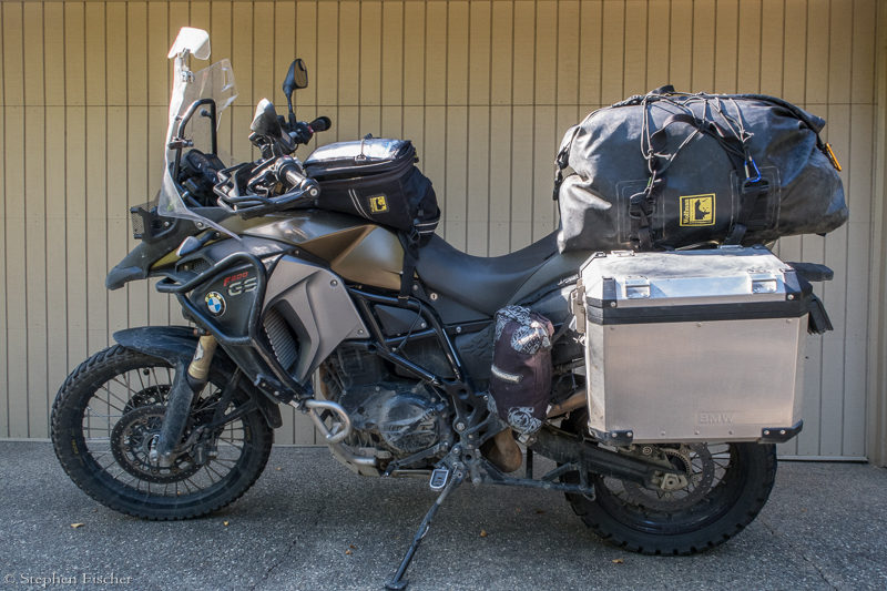
for my 2015 F800GSA motorcycle, it continues to do surprisingly well.
The bike was already outfitted and refined for this type of travel based
on earlier trips through
Baja to Cabo and back, the
Continental Divide
Route, and the
Pacific Divide Route. By this point I had beefed up the
suspension in the front with Hyperpro progressive springs, and a
Touratech rear shock, while also adding a Scott steering stablizer. With
its 6.3 gallon tank at 45 ~ 50 mpg, its range has not been a problem for any of these
trips including this one. Final readiness was completed by changing the
oil and swapping out the tires for some Heidenau K60s front and rear.
These tires have an incredible range, doing reasonably well in the dirt,
and held up for the entire 9000 miles. But given the amount of highway
miles, by the end they were looking awfully square and behaved fairly
bad on the asphalt twisties during the ride back. To help with my knees during the long
sections of pavement, I added a pair of fold down home-brewed cruiser pegs to the front crash bars in order to stretch my legs on.
In the end I didn't need the AirHawk seat pad that I have used on
previous long distance rides, and will probably limit its future use to longer
rides on my new 2020 Husqvarna 701 enduro. As for maintenance, regularly lubing the chain and changing the engine oil at the half-way point in Fairbanks was also key to keeping the bike in top mechanical shape. With over 45K miles on this 5 year old motorcycle, I have still not had any mechanical issues unrelated to some type of crash or other such rider induced problem.
At the end, I would have to say I am glad I did it. The adventure of this type of trip and the experiences along the way are not something I will soon forget. Yes, some of the long days on the asphalt were a pain. But as we got deeper into the Northwest of Canada and Alaska, the effort endured to get there was worth it. Each day I would have some new experiences or encounters with others that would further expand my horizon. This is one of my favorite aspects about long distance travel by adventure motorcycle.
- Stephen Fischer
Video of the ride up the Dempster Highway to Tuktoyaktuk
 A YouTube video is posted
here. This
is 15:33 long, covering the 3 days of riding up the Dempster Highway from Dawson City to Tuktoyaktuk, and includes
a slide show of photos taken along the ride. This
should give the viewer a pretty good idea of the type of terrain encountered
on this ride, and what other adventure motorcyclists should expect if
planning a ride up the Dempster.
Motorcycle packing list
See this link for my motorcycle trip packing list.
GPS tracks
In the following list you will find the GPS
track files in .gpx format as captured from my GPS for this ride described.
To download each track, right-click each link, and select "Save As" to save
the file to your local computer.
Disclaimer: As for the tracks I am providing below, I tried to edit these for the more blatant wrong turns to clean up some of this, but may have missed some. These tracks are provided as-is, and the author can not vouch for their accuracy or consequences of their use. Thus you should not soley rely on them, but instead use as an additional reference and apply reasonable common sense for your overall trip planning. In any case, you will find that roads or trails can change, or that weather can impact the passabiity of a particular route, and that it is typical that some improvisation during your travels will be required.
| Day | Segment | File |
| 1 | Sacramento, CA to Cottage Lake, OR | Alaska_06-28.gpx |
| 2 | Cottage Lake, OR to Bellingham, WA | Alaska_06-29.gpx |
| 3 | Bellingham, WA to Helen Lake, BC | Alaska_06-30.gpx |
| 4 | Helena Lake, BC to Sunset Lake, BC | Alaska_07-01.gpx |
| 5 | Sunset Lake, BC to Stewart, BC | Alaska_07-02.gpx |
| 6 | Stewart, BC to Watson Lake, Yukon | Alaska_07-03.gpx |
| 7 | Watson Lake, Yukon to Faro, Yukon | Alaska_07-04.gpx |
| 8 | Faro, Yukon to Dawson City, Yukon | Alaska_07-05.gpx |
| 9 | Dawson City, Yukon to Eagle Plains, Yukon | Alaska_07-06.gpx |
| 10 | Eagle Plains, Yukon to Inuvik, Northwest Territories | Alaska_07-07.gpx |
| 11 | Inuvik, Northwest Territories to Tuktoyaktuk and back | Alaska_07-08.gpx |
| 12 | Inuvik, Northwest Territories to Engineer Creek, Yukon | Alaska_07-09.gpx |
| 13 | Engineer Creek, Yukon to Tok, Alaska | Alaska_07-10.gpx |
| 14 | Tok to Fairbanks | Alaska_07-11.gpx |
| 15 | Fairbanks to Chena Hot Springs | Alaska_07-12.gpx |
| 16 | Chena Hot Springs to east end of Denali Highway (Seven Mile Lake) | Alaska_07-13.gpx |
| 17 | Seven Mile Lake to Valdez | Alaska_07-14.gpx |
| 18 | Valdez to McCarthy and back to Liberty Falls past Chitina | Alaska_07-15.gpx |
| 19 | Liberty Falls to Nabesena and back, then to Tok | Alaska_07-16.gpx |
| 20 | Tok, Alaska to Whitehorse, Yukon | Alaska_07-17.gpx |
| 21 | Whitehorse, Yukon to Dease Lake, BC | Alaska_07-18.gpx |
| 22 | Dease Lake, BC to Stewart, BC | Alaska_07-19.gpx |
| 23 | Stewart, BC to Co-op Lake (east of Burns Lake), BC | Alaska_07-20.gpx |
| 24 | Co-op Lake to Jasper (Robson Campground), BC | Alaska_07-21.gpx |
| 25 | Robson Campground, BC to Kootenay National Park, BC | Alaska_07-22.gpx |
| 26 | Kootenay National Park, BC to Lewiston, ID | Alaska_07-23.gpx |
| 27 | Lewiston, ID to Bend, OR | Alaska_07-24.gpx |
| 28 | Bend, OR to Mt. Shasta, CA | Alaska_07-25.gpx |
| 29 | Mt. Shasta, CA to Sacramento, CA | Alaska_07-26.gpx |
All content and images are property of Stephen Fischer Photography, copyright 2019 - 2020. Last updated: 1/10/2020