White Rim Trail
Stephen Fischer Photography
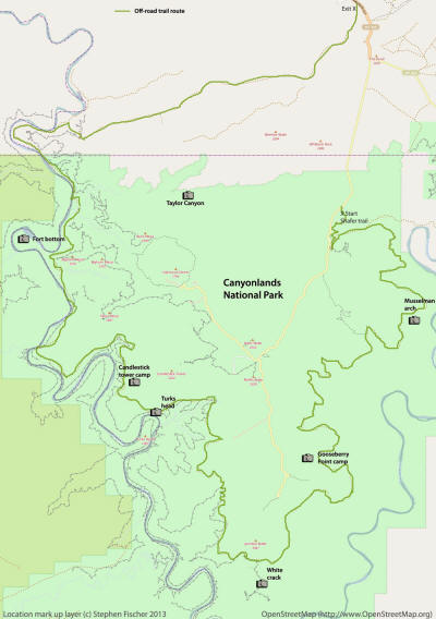
Myself and four other friends (Cliff, Don, Randy, and Tucker) took a 3 day trip along the White Rim Trail in the fall of 2012. The White Rim Trail follows the top edge of the main shelf of the Canyonlands National Park, with the Colorado river below on the east side, and the Green river to the west. You can see traces of this trail in the distance when up at the Grand View Point Overlook, or even from locations like Mesa Arch. This trail is about 100 miles long and requires a 4wd vehicle with reasonable ground clearance. I wouldn't say that the vehicle requires any type of high lift capability, but it definitely helps and I would be nervous taking a Subaru out here without more friends with a second vehicle as a backup. For overnight trips on this trail, a permit is required ahead of time. You will then be issued specific designated camp locations for each night based on your preferences and availability. You also need to be completely self-sufficient as far as fuel, water, and food is concerned. To reduce the negative impact to this area, they strictly limit the number of overnight visitors, and do enforce it.
 As
shown by the map to the right, we started on the first day descending down the Shafer Trail to the east,
stopping at the edge of the Goosneck overlook, exploring Musselman Arch, and
taking a side trip down Lathrop Canyon decending below the white rim to the edge of the Colorado River.
Back up on the rim, the trail then proceeds past the Washer Woman rock, as can
also be viewed from
Mesa Arch up on the canyon rim. One of the images shown here also shows Mesa
Arch from below, and gives you an idea of the expansiveness of this lower
canyon basin area and just the scale of this area in comparison to that popular
landmark. For the first night we camped at Gooseberry Point. We
also timed this trip to coincide with a full moon in order to maximize some
evening compositions as well.
The images below are sorted in chronological order of the trip with each page describing a different day of the trip.


