American River Parkway
Below is a clickable map of the parkway. Just hover over different pictures on the map to find links to separate images captured at that location. You can also find much more information about Sacramento County parks including the American River parkway by following this link to the Sacramento County park site.
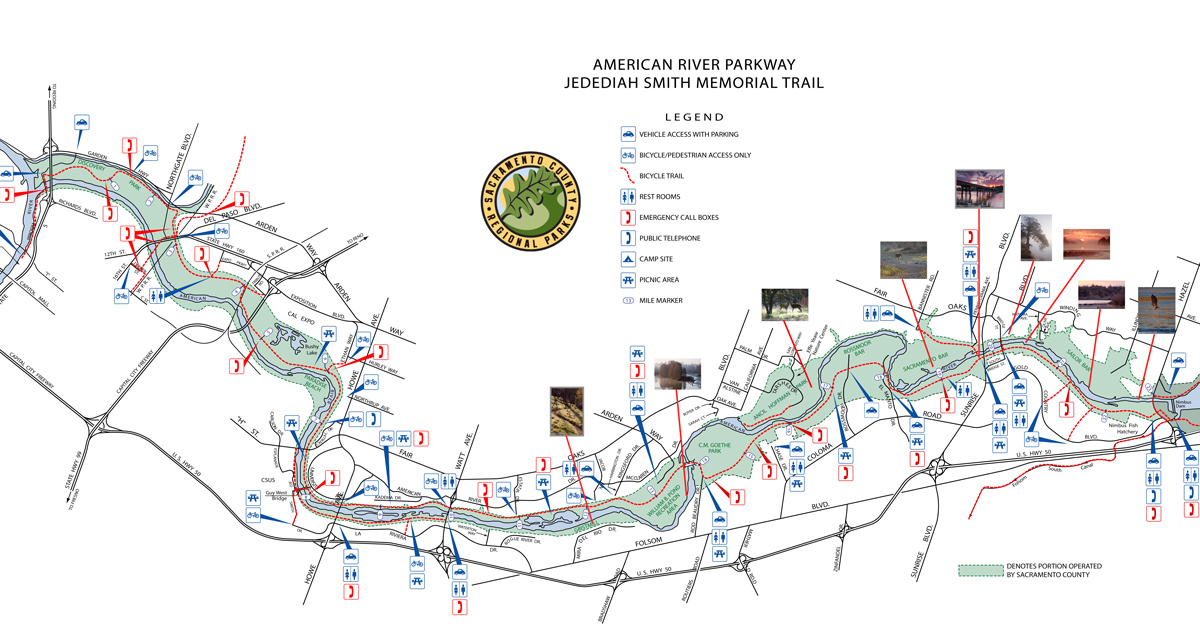
Map courtesy of Sacramento County
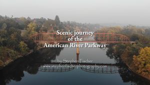
Video: Scenic journey of the American River Parkway
 A
7:26 long video of the American River Parkway as captured from the air under
smokey evening light. The area covered here spans from the Old Fair
Oaks Bridge to the eastern end of Sailor Bar. This video is also
produced in
conjunction with a slide show of some of my favorite images of the area.
A
7:26 long video of the American River Parkway as captured from the air under
smokey evening light. The area covered here spans from the Old Fair
Oaks Bridge to the eastern end of Sailor Bar. This video is also
produced in
conjunction with a slide show of some of my favorite images of the area.
1280
x 720 low bandwidth video
1920
x 1080 medium bandwidth video
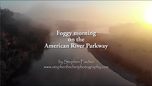
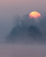
Video: Foggy morning on the American River Parkway
 A
5:44 long video of the American River Parkway as captured from the air on a
foggy morning, covering the river between the Old Fair Oaks Bridge and the
Nimbus fish hatchery.
A
5:44 long video of the American River Parkway as captured from the air on a
foggy morning, covering the river between the Old Fair Oaks Bridge and the
Nimbus fish hatchery.
1280
x 720 low bandwidth video
1920
x 1080 medium bandwidth video
|
|
|
| American River Parkway favorite locations | |
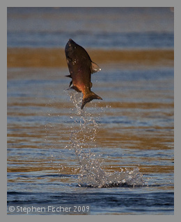 Nimbus Fish Hatchery |
The Nimbus fish hatchery is located at the most eastern end of the
free flowing section of the American River from its terminus into San Francisco bay.
This is as far as the fish can swim from the ocean.
Immediately upstream is Nimbus Dam the prevents the chinook salmon,
steelhead, or shad from going any
further in their (semi-) annual quest to spawn. The fish hatchery here is a popular family outing location during the late fall salmon run, watching them climb the fish ladder as they enter the processing area. There are some exhibits inside a visitor center where you can learn more about the salmon and the efforts at this facility to try to preserve this species. The Chinook salmon population has diminished signficantly in the last few decades. Part of the challenge has been to maintain sufficient water flows to support the chinook and other fish species on this river such as shad and steelhead trout, with agricultural and municipal water demands that have continued to increase as the population of the State has grown. The parking lot at the fish hatchery is also a popular location as a base for cycling or running from this end of the parkway. People take advantage of the fact that the parking is free here given this is a federally run facility while the parkway region further west is managed under Sacramento County. Sacramento County partially depends on these parking revenues to fund the upkeep and security in the rest of the American river parkway, so unfortunately this ends up hurting the parkway's cause. Recent budget cuts have threatened this upkeep and overall livelihood of the parkway, so those that enjoy its use and wish take full advantage of it in the future are encouraged to purchase an annual Sacramento County park pass. That will also give you unencumbered access to all the other areas of the parkway worthy of exploring as covered below. You purchase an annual park pass from Sacramento county here or at the local REI outdoor sports store for $50. |
 Sailor Bar |
Sailor bar is
a popular area for launching fishing boats and kayaks on the
American River Parkway from the north side in Fair Oaks off of
Illinois avenue. A former access point on the west side off Toyon
way has since been closed due to parkway budgetary concerns.
But both entrances are used by locals that are within walking
distance of these areas. The terrain on land primarily consists of
dredge tailings from the historical dredger based mnining that was
performed here up to the 1960's. Because of this limited vegation,
other than the boat launch area it is one of the lesser visited
areas of the park. But also during the fall chinook salmon run
or winter steelhead run, it is popular with the fishermen wading
from the shoreline. About the midsection of Sailor bar down along the bank you can find some old grinding holes. It is speculated that the native American Indians (Nisenan) settled along these banks and created these holes when grinding acorns into flour. From a photographic potential standpoint, the landscape is less remarkable. But you will find numerous wildflowers in the spring and some wildlife including deer and coyotes that tend to hang out in the areas with less people traffic. |
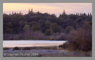
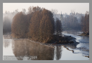
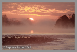 Upper Sunrise |
The upper
sunrise area in the author's opinion has some of the most
picturesque areas of the parkway. During the cooler months it is
common to find mist or fog rising off of the water in the morning
hours. This can add a nice ethereal look to your photographs.
The river tends to be more east-west in its heading, which provides
more opportunities for capturing beautiful sunrises or sunsets with
the river in the foreground.
During fall and winter sometimes you can typically walk out in ankle
deep water to some of the
gravel bars toward the center of the river to get some better vantage
points. Having some taller rubber boots or fishing waders can be helpful
if you want to stay dry. You can reach the Upper Sunrise area by entering the parkway from park entry at the south-east corner of Sunrise boulevard and the American River (by the raft rental and kayak store). After passing the kiosk at the entrance, make a right at the tee and follow this road to the right past the first parking lot on the left by the Fair Oaks bridge. Proceed another 1/4 mile to the east and park on the right (there will be large mounds of dredge tailings on the south side of the road. You will known when you have gone too far when the road starts to veer away from the river again and up a hill. |
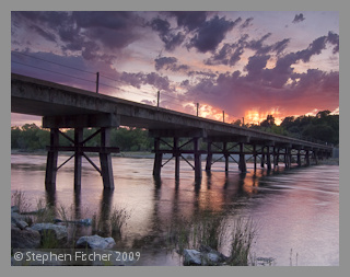
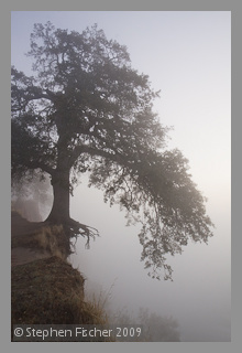 Fair Oaks bluff |
The Fair Oaks
bluff is a popular hangout for the locals due to its easy access off
of Bridge street from the Fair Oaks side. It is located on the bluff
just west of the old Fair Oaks pedestrian bridge. This bluff offers
terrific views of the river and the Sacramento valley as a whole to
the south. When up here you will realize that this bluff
lines the north side of the American River, representing the first significant landrise across the Sacramento
Valley all the way to the coastal foothills. On well recognized landmark up here is the hanging tree. This oak tree has half of its root system exposed in the air as the bluff edge has slowly eroded underneath. It is only a matter time before some significant enough storms undermines the ground that this oak stands on. It can be a nice tree to photograph at both sunrise or sunset, depending on the lighting, clouds, or fog off the river you may have to work with. The Fair Oaks bridge is also a popular landmark in the area and pleasing to photograph as well. You can capture images from up on the bluff or down below on the rivers edge, or even down river from the Sunrise blvd bridge. This bridge was also a center piece in movie starring Peter O'Toole and Barbara Hershey made in the late 70's called "The Stunt Man". One word of caution in visiting this area: Don't park on Bridge street. There is a certain criminal grunge element in the old Fair Oaks neighborhood that preys on visitors to this area. Cars are broken into on a regular basis here, and I personally have witnessed victims commiserating the situation twice in the various times I have visited this area. It is hard to catch the perpetraters here since they can cross the bridge and escape into the parkway, go up Bridge street, or escape through yet another small trail from the top of the bluff into the local neighborhood. They can be on foot, BMX bikes, or a waiting vehicle on the south side of the bridge. So unless law enforcement stakes out all 3 locations, theives here are able to easily get away. As a precaution I tend to avoid parking on even the south side of the Fair Oaks bridge in the parkway for the same reason in the evening hours when hooligans are more prevalent. So if you plan on visiting this area in the evening hours, park further away such as Upper or Lower Sunrise and just plan on a bit longer walk. |
 Lower Sunrise |
Lower Sunrise
is probably one of the most popular location for visitors to the
American River Parkway. It is a very convienent location for putting
in for rafting or kayak trips down the lower American River. There
is a raft rental company on the southeast corner of Sunrise blvd.
and the American River that is within walking distance of this spot.
This is the location for the bicycle-to-kayak relay stage for Eppies
Great Race held here every July (argueably the first triatholon). This is also popular junction for cyclists and runners as there is ample parking for even the weekends crowds on a warm spring or summer day. Jim's bridge is also located here. It was formerly operated by a gravel company when they processed aggregate rock from the past dredge tailings. At one point the county planned on dismantling the bridge when the gravel operations stopped. But locals as led by Jim Jones helped preserve it for pedestrian use. As a result, today it offers another convenient crossing point of the American River for neighborhoods on the other side without having to deal with the car traffic on the much busier Sunrise boulevard. If you hang out around the Lower Sunrise area enough, you may run into Jim from time to time, especially during the bi-annual volunteer river clean-up efforts. |
 Sacramento Bar |
Sacramento bar
is located on the north side of the American River starting on the
east side by Jim's bridge. It stretches down about 1-2 miles to the
west as bounded by the river as it bends to the right and then to
left at San Juan rapids. The landscape is a mix of dredge
tailings, some ponds as created by previous mining activity, with
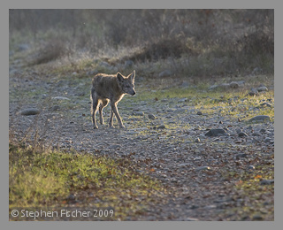
cottonwoods, oaks, and willows covering much of the area. Although there is a bike path that passes through the north edge of this area up to Bannister park from Jim's bridge, this is somewhat far from the river bar area. Because of this, it is a more remote area of the parkway and visited more by the locals either running on some of the gravel trails that snake through the area, bird watchers, or folks walking their dog. It is remote enough that many people let their dog run loose without fear of hassling or being hassled by others. You can enjoy this area without the typical stress of cyclists zooming by as you may notice for areas closer to the paved trails. Due to this remoteness, there also tends to be a little more wildlife here such as that coyote shown in the image to your left. |
 Effie Yeaw Nature Center |
The
Effie Yeaw Nature Center is one of those underappreciated, yet
remarkable places in the American River Parkway. It is
sponsored and operated by the non-profit
ARNHA (American River Natural History Association), as
previously transferred from
Sacramento County after an earlier budget crisis. It is has played a critical role in educating
school age children on the value of nature and raised
their awareness of our natural history and current ecology of this
region. It is also a wildlife refuge where animals such as
deer and various bird species can be found in abundance and
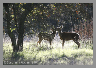
protected from outside harrassment. If you plan on photographing deer, then this is the place. It can be like walking into the midst of a wildlife park. They are relatively tame and seem to be aware of their special protection status of this area. With that in mind be aware that visitors need to stay on the designated trails in order to preserve their habitat. Wild turkeys at this location also seem to be aware they enjoy the same benefit. Effie Yeaw is accessed from Tarshes drive off of California avenue from the Carmichael side of the river. The Ancil Hoffman golf course is also located in this section of the park. After driving past the kiosk you will reach a junction, with the left fork taking you to the nature center another 1/2 mile down the road. |
 River Bend and William Pond parks |
River Bend Park (formerly known as Goethe
Park, named after the original donor
of this land, but in which the name was changed out of political
correctness concerns) is located on the east side of the river.
William Pond park is located on the west side of the river (named
after the citizen who spearheaded the effort to create the American
river Parkway and protecting this space from private development).
The two parks are connected across the river by another
bicycle-pedestrian bridge constructed in the 80's. These parks also represent major visitor junctions similar in magnitude to Lower Sunrise. River Bend Park is very accessible from the city of Rancho Cordove on the south side of the river off of Folsom boulevard, while William Pond Park is similarily accessible from some of the more established upscale neighborhoods of east Sacramento on the north side of the river via Arden boulevard. The River Bend Park side of the river is also one of the most popular take-out spots for rafters starting further upriver at Lower Sunrise. During the summer months both of these parks can be extremely popular with picnicers, rafters, cyclists, people who just would like to enjoy the outdoors near the river. |
 Gristmill |
Gristmill is
accessed off of Mira Del Rio drive from Folsom boulevard in Ranch
Cordova. It is not as well known or publicized as you must drive
through some residential neighborhoods to reach the entrance.
The area has some nice walking paths popular with the locals that
wind through oak woodlands along the southern bank of the river in
either direction from the parking area. In addition to the
usual assortment of birds in these woodlands such as Nutall's
woodpeckers, Norther Flickers, Red Shouldered hawks, it is not
unusual to spot deer and coyote here as well. The river has a
east-west direction from this area, so like Upper Sunrise it can be
nice for morning or evening photography. Gristmill is also a great put-in location for kayakers and canoers that don't want to deal with the logistics of having a separate car further down river for us as a shuttle. That is because the river flow is fairly gentle in this area for about 1/2 mile in either direction. If you keep in mind your position and test your paddling skills first, most people may find it fairly easy to go up or down the river this same distance and still be able to get back to your put-in location. There are also some nice tributaries on the northern bank of the river just down stream from Gristmill that you can explore by kayak or canoe. It is a popular location for spotting beaver, muskrat, or river otter, plus various water birds along the banks. Early morning or evening is best. |
 For
a selection of high quality fine art images of the American River Parkway, you can visit my
For
a selection of high quality fine art images of the American River Parkway, you can visit my
photographic gallery here:
All content and images are property of Stephen Fischer Photography, copyright 2009-2015. Last updated: 12/20/2015.